Posts

Image
  The satellite camera took the frames for this video clip once every 5 minutes.  This clip runs from about 7 am eastern daylight time to about 9 am  and compresses the 2 hours into about 1 sec .  Notice we can see solar illuminated clouds light-up as the sunrise sweeps across the photo from right to left.  The camera automatically switches from infrared to visible light through this process.  Notice after the Sun rises the city lights are no longer visible, the satellite no longer sees through the thinner outlying clouds over the Carolinas and Georgia.  Finally notice that the outlying clouds are rotating clockwise, opposite the rotation of the hurricane's core.  Click HERE to go back to the main page for an explanation of the rotation of hurricanes and cyclones.
Image
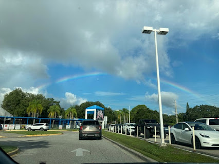
  September 23, 2022 Moon under a Rainbow - Photo from Sarasota, Florida by Briana Bryant If you look carefully at this image underneath the top of the rainbow you can make out an image of a nearly full Moon.  It's highly unusual to see such an occurrence. First, in order to see a rainbow we need both sunshine and rain.  We must look in the opposite direction of the Sun.  In order to have the rain, most likely the rain would come from a cloud that is in the distance causing the rain.  The raindrops reflect the sunlight by means of the light entering the drops, and internally reflected from the far side of the raindrops, and back to the observers.  As the light enters and leaves each surface the light is bent, and the amount of bend in the light depends on the index of refraction* of the water drop.  Different colors of light exhibit a different index of refraction in water.  That means that the different colors emerge at slightly different angl...
Image
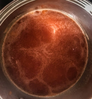
September 9, 2022 Soupy Physics When tomato soup is heated in a saucepan, we can often see the tops of convection cells.  The darker areas of the soup surface consist of the warmer soup that has risen from the bottom near the heat source.  The fluid spreads from the center of a rising column or, cell, and as the surface cools it falls back toward the bottom of the pan.  Where it falls, it tends to leave the small air bubbles that continue to float on top.  When you watch the soup - before it starts to boil - you can see the soup rising in the center of the cells and propagate towards the cell walls.       The picture at right shows a schematic diagram of the flow of the soup in the pan that is heated by a hot plate from below.  The convection cells are referred to as B énard cells named after the French physicist Henri B énard who studied them extensively in 1900.  The analytical fluid mechanics of the process is very complicated.  The ...
Image
August 26, 2022 Breaking Wave On "our" lake in northern Vermont (Willoughby Lake) where we have been all summer we are often treated to a morning of a fair wind with the moderate waves breaking on the beach shore.  These waves were about 0.3 meters high (about 1 foot).  As the waves reach the beach, the base of the wave becomes blocked by the shallower bottom of the lake, but the top of the wave keeps moving, until there is no water beneath the crest of the wave.  The wave curls abruptly and comes crashing down onto the beach in what is called a "curl". I used the "slo-mo" feature on my smart phone to capture the breaking wave in slow motion, which plays back repeatedly in the video clip below.     This clip shows the curl crashing onto the beach in the center of the photo.  Notice that when the curl breaks, a tube of air is trapped as a cylindrical cavity in the center of the curl.  Notice that after the curl crashes, the trapped air rapidly escapes ...

Physics Photo of the Week - Special Summer Break Post - May 20, 2022

Image
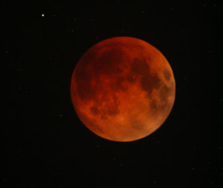
  Total Lunar Eclipse of May 15, 2022 - Photo by Donald Collins For approximately 1.5 hours on the night between Sunday, May 15 and Monday, May 16, 2022, the Moon appeared dramatically dimmed by being completely immersed in Earth's shadow.  Viewing this required staying up late - between 11:30 pm and 1:00 am - way past "prime time".  We also see a star visible in the upper left part of the image. Notice the deep red color of the Moon that usually appears white and bright when full and high in the sky.  Why should there be color in the shadow of the Earth when all the light from the Sun is supposedly blocked?  The answer may be explained by "leakage" of sunlight through the Earth's atmosphere, similar to seeing the red sky (when not too cloudy) after the Sun has set below the horizon or before rising at dawn.  The red sunset is caused by the long path through the Earth's atmosphere (almost tangent to the surface of the Earth) as the rays of sunlight pene...
Image
  Path of Thunderstorms - Map by CoCoRaHS; discussion by Donald Collins Earlier on this final week of the semester for Warren Wilson College (Tuesday, May 4, 2022) we had a fairly strong thunder storm that created some minor flooding near the campus, but was strongly localized.  No rain appeared in Asheville that afternoon after the storm passed WWC campus.  A map of rain gauge readings contributed by citizen science participants for the same date showed the rain pattern in definite bands ranging from the southeast towards the northeast USA.  The darker and more intense colors indicate a larger amount of rainfall. The image at right shows a spring-time thunderstorm over the Great Craggy Mountains near Warren Wilson College photographed about six years ago (May 12, 2016) and posted last spring on PPOW for April 30, 2021 .   (I was busy on an errand in Asheville during this week's storm and was unable to photograph this week's storm after it had passed.) Clic...

Graupel - not Hail - Photo by Don Collins

Image
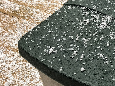
  In April, 2022, winter does not want to "give-up".  Many folks at Warren Wilson College noticed this "wintry mix" on April 9, 2022.  This wintry precipitation resembles Styrofoam beads, but on close inspection these "beads" are icy and some have melted to form liquid water.  Many said that they resembled hail because they consist of ice.  They are not hail - hail is formed by the strong convection updrafts in thunderstorms that form only in the summer season.  Graupel forms in a winter snowstorm under special conditions that only form in the winter.  Graupel is actually a form of sleet.   The graupel "beads" actually began as snow flakes from a snow forming cloud.  A snow-forming cloud requires a dew point within the cloud that is below the freezing point (0 deg C or 32 deg F).  The moisture in the cloud sublimates directly from the solid into frozen snow crystals.  As more of the snow crystals form, they fall randomly and of...