http://Physics Photo of the Week
March 18, 2022 - originally published Sept. 10, 2010
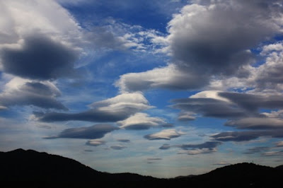
These clouds are even more spectacular when viewed with a time-lapse animation shown in the picture below. The time lapse animations are often published as UFO's. In the animation 30 frames are played back at 20 frames per second. The images were taken 10 seconds apart. This represents 5 minutes

These amazing formations only form when the air is very stable - when the air at higher altitudes is warmer than normal. On normal days, clouds form from rising air expanding due to lower pressure. As the air expands, the expansion is adiabatic or insulated from the surroundings, and the resulting falling temperature causes the water vapor in the air to condense into a cloud releasing a lot of heat called latent heat. The release of the latent heat prevents the cloud temperature from dropping any further. As a result the formation of a cloud usually raises its temperature higher than the surrounding air; the cloud becomes even more buoyant - an unstable situation. The normal instability leads to the familiar puffy cumulus clouds. However, if the surrounding temperature in the higher layers of the atmosphere is warmer than normal, the rising air from cloud formation loses its buoyancy and doesn't rise any further and eventually sinks back down. The thermal inversion creates a stable situation and we don't have the puffy clouds typical of convection.

======================================================================
Physics Photo of the Week is published weekly during the academic year on Fridays by the Warren Wilson College Physics Department. These photos feature interesting phenomena in the world around us. Students, faculty, and others are invited to submit digital (or film) photographs for publication and explanation. Atmospheric phenomena are especially welcome. Please send any photos to dcollins@warren-wilson.edu.
All photos and discussions are copyright by Donald Collins or by the person credited for the photo and/or discussion. These photos and discussions may be used for private individual use or educational use. Any commercial use without written permission of the photoprovider is forbidden.


Comments
Post a Comment