Physics Photo of the Week
March 11, 2022 - originally published February 16, 2018
Flyways
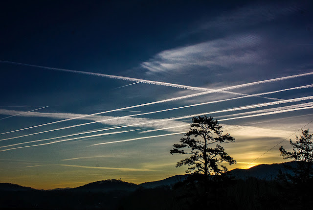
We woke up on January 16, 2018 to a cold (15 deg F = -10C) morning featuring a nearly cloudless clear sky plus many contrails from commercial jets on their flyways with destinations southeast of Warren Wilson College (Atlanta, Florida). The contrails were very persistent judging from the various widths as they eventually disperse before evaporating.
Jet contrails
("condensation trails") consist mainly of condensed water vapor as one
of the products of burning jet fuel (essentially kerosene). The water
vapor rapidly freezes into tiny ice crystals in the cold evironment (-
40 deg F = - 40 C) at the altitude of commercial air flight. Another
byproduct of combustion is tiny soot particles. The soot particles
provide the nucleation sites that enable the water vapor to condense
upon, otherwise the trail of the aircraft would be super cooled and
remain as an invisible vapor for long periods.
The
atmospheric condition must also be in a certain range in order for the
contrails to become visible. That condition is that the relative
humidity at the altitude (33,000 ft ~ 10,000 m) must be high enough that
water vapor from the aircraft "prefers" to condense rather than remain
as vapor. If the air is close to saturation, an influx of water vapor
from a source is more likely to condense. Thus many clear, cloudless
days occur soon after the influx of cold air behind a cold front that
pushes all the moist, rainy air out of the area, and no contrails are
visible. After several days the winds aloft shift their direction away
from the north to coming from the south. The winds from the south carry
moisture from the Gulf of Mexico. The added moisture at first is not
enough to form clouds, but enough to prevent the evaporation of
contrails and to increase the tendency to condense on the soot
particles. These were indeed the conditions in the upper atmosphere on
the day of these persistent and numerous contrails. Later that day the
whole sky was covered with a thick stratus of clouds (making astronomy
observing impossible...) followed by about 2 inches of snow that night.
Another
indication of ice crystals in the upper atmosphere is the appearance of
a sun pillar. The soon-to-rise Sun below the mountain ridge in the
lower right of the photo is indicated by a vertical band of red
reflected sunlight. The ice crystals in the thin clouds are tiny
hexagonal plates that are mainly horizontal as the crystals fall through
the atmosphere. These horizontal crystals act as millions of miniature
mirrors that reflect sunlight in the vertical plane forming the sun
pillar. At other times the ice crystals refract the sunlight when the
Sun (or Moon) is higher and form Sun (or Moon) halos that have been
frequent topics of Physics Photo of the Week.
Physics Photo of the Week is published weekly during the academic year on Fridays by the Warren Wilson College Physics Department. These photos feature interesting phenomena in the world around us. Students, faculty, and others are invited to submit digital (or film) photographs for publication and explanation. Atmospheric phenomena are especially welcome. Please send any photos to dcollins@warren-wilson.edu.
All photos and discussions are copyright by Donald Collins or by the person credited for the photo and/or discussion. These photos and discussions may be used for private individual use or educational use. Any commercial use without written permission of the photoprovider is forbidden.


Comments
Post a Comment