Physics Photo of the Week
Physics Photo of the Week
April 7, 2023
Cumulus Cloud "Front" - photos by Donald Collins
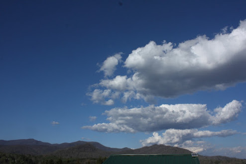
This looks like a normal spring day with scattered fair-weather clouds. A nice day to enjoy the spring!However, this photo presents an odd appearance of the familiar fair-weather clouds. The clouds fill only the right half of the image. On closer examination, the clouds all seem to be lined up and form a line extending several miles into the distance. This line of rising clouds represents a type of "weather front". The photograph is looking east over the Great Craggy Mountains of North Carolina. Warren Wilson College is close by, off the lower left side of the photo.
 A time-lapse (highly sped-up) video of the clouds in the video at right shows another amazing fact about these clouds. The clouds are all forming along the frontal line that lines up between west and east. The tops of the clouds are being blown to the right (south) by the higher-level breeze out of the north. The bases of the row of clouds remain stationary while the rising air straight up into the base of the clouds. The time lapse video clip compresses about 6 minutes into about 1.5 sec of playback which repeats continuously.
Cumulus clouds are simple clouds caused by convection - air at ground level is heated by sunlight. The warm air rises to higher elevations (a few thousand feet) where the temperature drops and causes the moisture in the air to condense forming the cloud. Often the cumulus clouds reach much higher elevations before they are "blown away". There was hardly any breeze at ground level in contrast to the clouds' level. This represents wind shear - the wind blows at different velocities at different altitudes. In thunderstorm season the clouds often rise to heights of 30,000 feet to 50,000 feat and form thunderstorms. Thunderstorms do not form when there is a lot of wind shear that "tear the clouds apart".
We see the clouds actually forming in the center of this image. They are caught by the upper level wind and blown down wind. The clouds at the front actually evaporate soon after reaching the wind's level. Clouds a little further downstream in the wind become larger, but still disappear further downstream. No clouds at all come in from the left in the image. The line of clouds mark a definite change in the weather conditions at the cloud front. The change could be a sudden spatial change in humidity, a sudden change in temperature, or even barometric pressure. If the air over the left were descending (causing a higher relative barometric pressure) that would prevent the formation of rising cumulus clouds in that region. Without knowledge of the local variations in these weather conditions, it is impossible to know what is causing this effect. Experienced small airplane pilots may be able to figure out what is causing this abrupt change in the number of cumulus clouds by comparing the turbulence or lack of turbulence in different parts of this region. My friend Dennis Stockdale has had considerable piloting experience. He has flown through "solid" clouds relying only on instruments and has had smooth rides. He has also flown through very clear sunny skies and experienced severe turbulence (Clear Air Turbulence - CAT) supposedly caused by cloudless convection. I suspect that convection and turbulence exist on both sides of the "front" featured in this week's photo and that the left part of the image has clear air turbulence - turbulence without clouds in which the convection would not produce clouds. Thank you, Dennis, for your input!
These clouds were photographed six years ago at the same time of year (April, 2017).
======================================================================
Physics Photo of the Week is published weekly during the academic year on Fridays by the Warren Wilson College Physics Department. These photos feature interesting phenomena in the world around us. Students, faculty, and others are invited to submit digital (or film) photographs for publication and explanation. Atmospheric phenomena are especially welcome. Please send any photos to dcollins@warren-wilson.edu.
All photos and discussions are copyright by Donald Collins or by the person credited for the photo and/or discussion. These photos and discussions may be used for private individual use or educational use. Any commercial use without written permission of the photoprovider is forbidden.


Comments
Post a Comment