Posts

Image
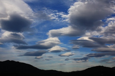
http:// Physics Photo of the Week  March 18, 2022 - originally published Sept. 10, 2010 It looks like an invasion of flying saucers invading the Swannanoa Valley.  Actually these are lenticular clouds - clouds that are shaped like lenses.  This is an unusual display that occurred Sept. 9, 2010 and lasted from before 5:30 pm until past sunset 3 hours later.  These clouds are even more spectacular when viewed with a time-lapse animation shown in the  picture below.  The time lapse animations are often published as UFO's.  In the animation 30 frames are played back at 20 frames per second.  The images were taken 10 seconds apart.  This represents 5 minutes of clouds condensed to 1.5 seconds - a speed-up factor of 200.  Notice how the clouds are all stationary as the winds blow through them.  These stationary patterns kept their place in the sky at least an hour.  Notice also that high level cirrus clouds can be seen in the back...
Image
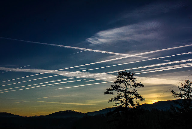
Physics Photo of the Week March 11, 2022 - originally published February 16, 2018 Flyways We woke up on January 16, 2018 to a cold (15 deg F = -10C) morning featuring a nearly cloudless clear sky plus many contrails from commercial jets on their flyways with destinations southeast of Warren Wilson College (Atlanta, Florida).  The contrails were very persistent judging from the various widths as they eventually disperse before evaporating. Jet contrails ("condensation trails") consist mainly of condensed water vapor as one of the products of burning jet fuel (essentially kerosene).  The water vapor rapidly freezes into tiny ice crystals in the cold evironment (- 40 deg F = - 40 C) at the altitude of commercial air flight.  Another byproduct of combustion is tiny soot particles.  The soot particles provide the nucleation sites that enable the water vapor to condense upon, otherwise the trail of the aircraft would be super cooled and remain as an invisi...

Physics Photo of the Week - Feb 18, 2022

Image
Physics Photo of the Week Feb. 18, 2022  Frosty Silk On the morning of Jan 4, 2022 we woke up to a very rare occurrence of rime ice on the trees in our yard.  I believe the temperature was not terribly cold but a few degrees below freezing.  This resembles ordinary frost that forms on surfaces, but believe it is rime ice judging from the long needle-like crystals forming on all the spruce needles as well as along a couple of old spider silks that stretched between small spruce branches.   This phenomenon is rime ice that was formed from supercooled fog that had descended on our yard during the night.  The fog droplets were below freezing temperature but still liquid when they were suspended as fog.  As soon as the droplets contacted an object (spruce needle, spider web, leaf point, or airplane wing) they freeze instantly.  Rime ice is different from "ordinary frost" or "hoar  frost" in that hoar frost forms by direct sublimation of water vap...

Physics Photo of the Week

Image
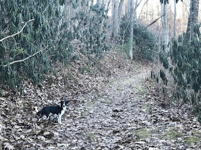
Nature's Thermometer - Rhododendron Leaves   Rhododendron leaves are a good temperature indicator, especially when the temperature is between 20 deg F and 32 deg F.  The leaves shrivel up and practically point downwards.  The plants look like they are shriveling up to die! But no, they are merely responding to the significantly below freezing ambient temperature which was about 20 deg F (-7 deg C).  The next day, Jan 8, 2022, the temperature was above freezing.  The second picture shows my dog investigating the warmer rhododendron leaves that have fully "recovered" I do not know why or how the leaves respond to temperature like this.  Since it is a physical phenomenon about the temperature that water freezes, it is perhaps a mechanism in which the water in the leaves' cells freezes and the cell walls can stretch to accommodate the the larger volume of the water.  Some plants are destroyed by freezing temperatures - presumably because the expansion of t...