Posts

Physics Photo of the Week - Special Summer Break Post - May 20, 2022

Image
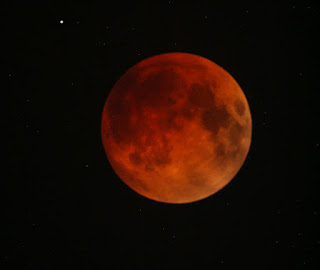
  Total Lunar Eclipse of May 15, 2022 - Photo by Donald Collins For approximately 1.5 hours on the night between Sunday, May 15 and Monday, May 16, 2022, the Moon appeared dramatically dimmed by being completely immersed in Earth's shadow.  Viewing this required staying up late - between 11:30 pm and 1:00 am - way past "prime time".  We also see a star visible in the upper left part of the image. Notice the deep red color of the Moon that usually appears white and bright when full and high in the sky.  Why should there be color in the shadow of the Earth when all the light from the Sun is supposedly blocked?  The answer may be explained by "leakage" of sunlight through the Earth's atmosphere, similar to seeing the red sky (when not too cloudy) after the Sun has set below the horizon or before rising at dawn.  The red sunset is caused by the long path through the Earth's atmosphere (almost tangent to the surface of the Earth) as the rays of sunlight pene...
Image
  Path of Thunderstorms - Map by CoCoRaHS; discussion by Donald Collins Earlier on this final week of the semester for Warren Wilson College (Tuesday, May 4, 2022) we had a fairly strong thunder storm that created some minor flooding near the campus, but was strongly localized.  No rain appeared in Asheville that afternoon after the storm passed WWC campus.  A map of rain gauge readings contributed by citizen science participants for the same date showed the rain pattern in definite bands ranging from the southeast towards the northeast USA.  The darker and more intense colors indicate a larger amount of rainfall. The image at right shows a spring-time thunderstorm over the Great Craggy Mountains near Warren Wilson College photographed about six years ago (May 12, 2016) and posted last spring on PPOW for April 30, 2021 .   (I was busy on an errand in Asheville during this week's storm and was unable to photograph this week's storm after it had passed.) Clic...

Graupel - not Hail - Photo by Don Collins

Image
  In April, 2022, winter does not want to "give-up".  Many folks at Warren Wilson College noticed this "wintry mix" on April 9, 2022.  This wintry precipitation resembles Styrofoam beads, but on close inspection these "beads" are icy and some have melted to form liquid water.  Many said that they resembled hail because they consist of ice.  They are not hail - hail is formed by the strong convection updrafts in thunderstorms that form only in the summer season.  Graupel forms in a winter snowstorm under special conditions that only form in the winter.  Graupel is actually a form of sleet.   The graupel "beads" actually began as snow flakes from a snow forming cloud.  A snow-forming cloud requires a dew point within the cloud that is below the freezing point (0 deg C or 32 deg F).  The moisture in the cloud sublimates directly from the solid into frozen snow crystals.  As more of the snow crystals form, they fall randomly and of...

M1 - the Crab Nebula - Photo by D. Collins, College View Observatory

Image
  The Crab Nebula - M1 in the Messier Catalog has been a popular item for the College View Observatory and Physics Photo of the Week.  This color photo required about 3 night sessions spread over 2-3 weeks last month obtaining and stacking many images through the different colored filters in order to create this color photograph. The Crab Nebula is the expanding remnant of a supermassive stellar explosion of a massive star dying.  The large progenitor star suddenly ran out of nuclear fuel and suddenly collapsed as a massive implosion.  A stellar implosion doesn't merely cause the star to disappear, but actually causes a massive rebound scattering the outer layers of the star far out into space.  This seems counter-intuitive.  How can an implosion cause a massive ex plosion? The answer may be explained by a simple demonstration that I used to do for physics and astronomy classes with a golf ball and ping pong ball.  In this experiment I would hold both ...
Image
http:// Physics Photo of the Week  March 18, 2022 - originally published Sept. 10, 2010 It looks like an invasion of flying saucers invading the Swannanoa Valley.  Actually these are lenticular clouds - clouds that are shaped like lenses.  This is an unusual display that occurred Sept. 9, 2010 and lasted from before 5:30 pm until past sunset 3 hours later.  These clouds are even more spectacular when viewed with a time-lapse animation shown in the  picture below.  The time lapse animations are often published as UFO's.  In the animation 30 frames are played back at 20 frames per second.  The images were taken 10 seconds apart.  This represents 5 minutes of clouds condensed to 1.5 seconds - a speed-up factor of 200.  Notice how the clouds are all stationary as the winds blow through them.  These stationary patterns kept their place in the sky at least an hour.  Notice also that high level cirrus clouds can be seen in the back...
Image
Physics Photo of the Week March 11, 2022 - originally published February 16, 2018 Flyways We woke up on January 16, 2018 to a cold (15 deg F = -10C) morning featuring a nearly cloudless clear sky plus many contrails from commercial jets on their flyways with destinations southeast of Warren Wilson College (Atlanta, Florida).  The contrails were very persistent judging from the various widths as they eventually disperse before evaporating. Jet contrails ("condensation trails") consist mainly of condensed water vapor as one of the products of burning jet fuel (essentially kerosene).  The water vapor rapidly freezes into tiny ice crystals in the cold evironment (- 40 deg F = - 40 C) at the altitude of commercial air flight.  Another byproduct of combustion is tiny soot particles.  The soot particles provide the nucleation sites that enable the water vapor to condense upon, otherwise the trail of the aircraft would be super cooled and remain as an invisi...

Physics Photo of the Week - Feb 18, 2022

Image
Physics Photo of the Week Feb. 18, 2022  Frosty Silk On the morning of Jan 4, 2022 we woke up to a very rare occurrence of rime ice on the trees in our yard.  I believe the temperature was not terribly cold but a few degrees below freezing.  This resembles ordinary frost that forms on surfaces, but believe it is rime ice judging from the long needle-like crystals forming on all the spruce needles as well as along a couple of old spider silks that stretched between small spruce branches.   This phenomenon is rime ice that was formed from supercooled fog that had descended on our yard during the night.  The fog droplets were below freezing temperature but still liquid when they were suspended as fog.  As soon as the droplets contacted an object (spruce needle, spider web, leaf point, or airplane wing) they freeze instantly.  Rime ice is different from "ordinary frost" or "hoar  frost" in that hoar frost forms by direct sublimation of water vap...